
GTS-220 series
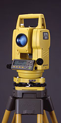 TOPCON proudly announces the debut GTS-220 Series as the innovative successor to the best selling GTS-210 Series Total Stations.
The GTS-210 Series with "Waterproof" design brought revolution to the surveying industry with features and durability.
Now the new GTS-220 Series has up-graded its basic functions for distance and angle measurement in addition to maintaining superb durability against the environment.
The GTS-220 Series is also provided with a longer life battery of 10 hours, and various kinds of application programs makes surveying work quick and simple in the field.
The features included with the "All Weather" highly productive GTS-220 Series Total Stations are setting a new standard for surveying!
| Model Name | GTS-223 | GTS-225 | GTS-226 | GTS-229 | ||||
TELESCOPE
| ||||||||
Length
| 150mm | |||||||
Objective Lens Diameter
| 45mm (EDM 50mm) | |||||||
Magnification
| 30 × | |||||||
Image
| Erect | |||||||
Field of View
| 1°30′ | |||||||
Resolving Power
| 2.5″ | |||||||
Minimum Focus Distance
| 1.3m | |||||||
DISTANCE MEASUREMENT
| ||||||||
Condition 1
1 prism
3 prisms
9 prisms
| 3,000m (9,900ft) 4,000m (13,200ft) 5,000m (16,400ft) | 2,000m (6,600ft) 2,700m (8,900ft) 3,400m (11,200ft) | ||||||
Condition 2
1 prism
3 prisms
9 prisms
| 3,500m (11,500ft) 4,700m (15,400ft) 5,800m (19,000ft) | 2,300m (7,500ft) 3,100m (10,200ft) 4,000m (13,200ft) | ||||||
| ||||||||
Accuracy
| ±(2mm + 2ppm× D)m.s.e. | ±(3mm + 3ppm× D)m.s.e. | ||||||
| D: Measuring distance (mm) | ||||||||
Least Count in Measurement
| ||||||||
Fine Mode
| 1mm (0.005 ft.)/0.2mm (0.001 ft.) | |||||||
Coarse Mode
| 10mm (0.02 ft.)/1mm (0.005 ft.) | |||||||
Tracking Mode
| 10mm (0.02 ft.) | |||||||
Measurement Display
| 11 digits: max. display 9999999.9999 | |||||||
Measuring Time
| ||||||||
Fine Mode
Coarse Mode
Tracking Mode
| 1mm: 1.2sec. (Initial 4 sec.) 0.2mm: 2.8sec. (Initial 5 sec.) 0.7sec. (Initial 3 sec.) 0.4sec. (Initial 3 sec.) (The initial time will be different by a condition and setting EDH off time.) | |||||||
Atmospheric Correction Range
| -999.9 to +999.9ppm (By 0.1ppm) | |||||||
Prism Constant Correction Range
| -99.9 to +99.9mm (By 0.1mm) | |||||||
ANGLE MEASUREMENT
| ||||||||
Method
| Absolute Reading | |||||||
Detecting System
| H: 2 sides V: 1 side | H: 1 side V: 1 side | ||||||
Minimum Reading
| 1″/5″ (0.2 / 1mgon) | 5″/10″ (1 / 2mgon) | ||||||
Accuracy *
| 3″ (1mgon) | 5″ (1.5mgon) | 6″ (1.8mgon) | 9″ (2.7mgon) | ||||
Measuring Time
| Less than 0.3 sec. | |||||||
Diameter of circle
| 71mm | |||||||
DISPLAY
| ||||||||
Display Unit
| Dot matrix LCD 20 characters × 4 lines with Blacklight | |||||||
| 2sides | 1side | |||||||
Keyboard
| 10 function keys | |||||||
TILT CORRECTION (AUTOMATIC INDEX)
| ||||||||
Tilt sensor
| Dual axis | Single axis | ||||||
Method
| Liquid type | |||||||
Compensating range
| ±3′ | |||||||
Correction unit
| 1″ (0.1 mgon) | |||||||
OTHERS
| ||||||||
Instrument height
| 176mm(6.93in) | |||||||
LEVEL SENSITIVITY
| ||||||||
Circular level
| 10′ / 2mm | |||||||
Plate level
| 30″ / 2mm | 40″ / 2mm | ||||||
LASER PLUMMET : STANDARD
| ||||||||
OPTICAL PLUMMET TELESCOPE (OPTION)
| ||||||||
Magnification
| 3 × | |||||||
Focusing Range
| 0.5m to infinity | |||||||
Image
| Erect | |||||||
Field of view
(at 1.3m)
| 5°(dia.114mm) | |||||||
DIMENSIONS
| ||||||||
| 336(H) × 184(W) × 150(L)mm [13.2(H) × 7.2(W) × 5.9(L)in.] | ||||||||
Weight
| ||||||||
Instrument
(with battery)
| 4.9kg (10.8 lbs.) | |||||||
Plastic carryng case
| 3.2kg (7.1 lbs.) | |||||||
DURABILITY
| ||||||||
Water protection
| IPX 6 (with BT-52QA) | |||||||
Ambient temperature range
| -20°C to +50°C (-4°F to +122°F) | |||||||
BATTERY BT-52QA
| ||||||||
Output voltage
| 7.2V | |||||||
Capacity
| 2.7AH (Ni-MH) | |||||||
Maximum operating time at +20°C(+68°F)
| ||||||||
Including distance measurement
| 10 hours (12,000 points) | |||||||
Angle measurement only
| 45 hours | |||||||
Weight
| 0.3kg (0.7 lbs.) | |||||||
BATTERY CHARGER BC-27BR / 27CR
| ||||||||
Input Voltage
| AC120(BC-27BR) AC230(BC-27CR) | |||||||
Frequency
| 50 / 60Hz | |||||||
Recharging Time
(at +20°C/+68°F)
| 1.8 hours | |||||||
Operating temperature
| +10°C to +40°C (+50°F to +104°F) | |||||||
Weight
| 0.5kg (1.1 lbs.) | |||||||
Langgan:
Catatan (Atom)


